Margam Castle Case Study
When tasked with capturing a historic refurb project at the sprawling 25,000m² Margam Castle in Wales, we at Sova Surveys knew we faced a complex measured building surveying and BIM modelling challenge.

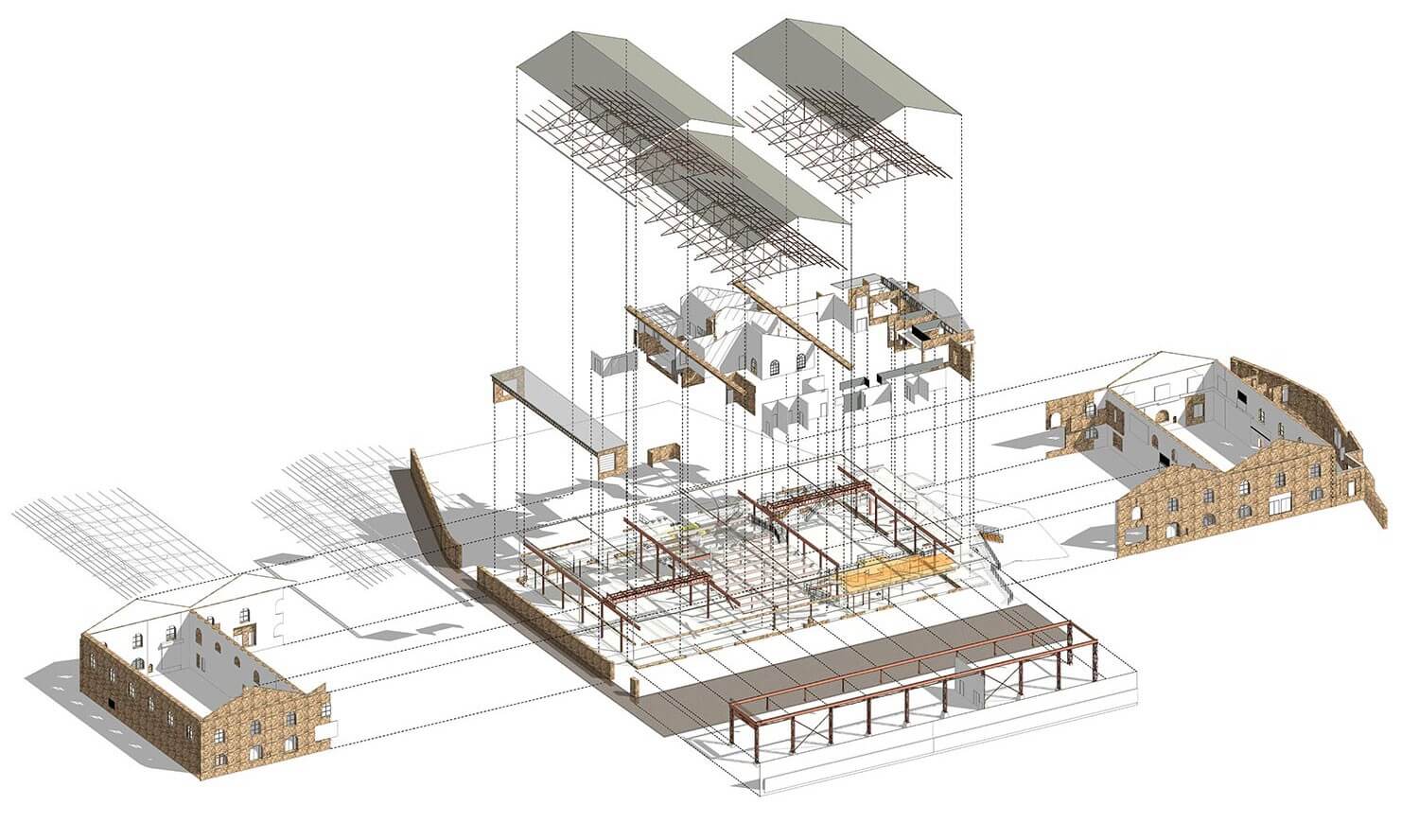
Game-Changing Historic Building Capture
The client required a highly detailed BIM model, with LOD200 coverage of most areas and LOD400 for significant architectural features like the ornate central staircase. To minimise disruption, we would need to quickly scan high-traffic public areas that needed to remain open within a fleeting period of 2 hours.
Traditionally, a project like this would rely on Sova’s standard laser scanning workflow – establishing survey control with a total station, capturing interior and exterior data with terrestrial laser scanners (TLS), and taking supplementary 2D photographs. While able to achieve the required accuracy, this approach is slow in comparison to BIM and 3D modelling, especially when dealing with restricted access, convoluted layouts, and capturing fine decorative details. Scanning public and tricky areas with TLS equipment would have been possible, but it would have pushed us beyond the allotted time the client had available, which would have disrupted their business more than was necessary.

The Mobile Mapping Solution
Having evaluated various mobile mapping technologies over the years, we discovered the solution to their problems with NavVis VLX – a wearable, mobile scanning system that uses simultaneous localisation and mapping (SLAM) to rapidly capture fully panoramic, high-resolution point clouds and imagery.
Our BIM experts tested the NavVis VLX against their standard laser scanning workflow, with the TLS as a backup. The mobile point cloud was on point in terms of accuracy when comparing the data with Sova’s equipment and would prove capable of capturing the data in a fraction of the time.
For Margam Castle, we employed a hybrid methodology using both TLS and the NavVis VLX mobile mapping product. We used conventional survey methods to establish control and capture high-detail areas like the central staircase at LOD400. Following this, we were then able to rapidly walk through the rest of the castle’s complex layout with the VLX to build out comprehensive point cloud and panoramic imagery data.
With the NavVis VLX, it took about two days of scanning to capture everything we needed,” said Jared Matthews, Sova Surveys Director. “Using our Trimble, it would have taken us 10 days. To cut 10 days down to two while hitting the accuracy we needed? That’s much, much better for us.” The time saving was invaluable, and minimised impact on the client’s day-to-day operations as a popular tourist attraction.
Rapid Workflows
The time savings didn’t stop at the data capture phase; we found that NavVis’ SLAM-based scanning and integrated cloud processing also streamlined their downstream modelling workflows.
In the past, modellers would have to painstakingly comb through individual scan data, photos, and even do virtual walkthroughs trying to interpret details. The VLX and IVION software provides colourised point clouds and panoramic imagery to provide easier-to-digest top-level information in one environment, making it much more efficient.
The client was impressed with the process and technology, proclaiming how much they loved being able to revisit the complete capture data themselves without having to physically be on-site.
What Our Clients Say
Benefits Beyond Efficiency
While the massive time savings were invaluable, the NavVis solution provided additional benefits beyond just pure efficiency for Sova.
- Increased project scope: Since the NavVis mobile scan was so fast, we were able to offer to scan Margam Castle’s stables at no extra cost – expanding the deliverables beyond the original scope.
- Higher client satisfaction: The client was impressed by the VLX data quality, IVION viewer capabilities, and the overall speed of Sova’s NavVis-enabled workflow. This high satisfaction has already led to them awarding Sova additional historic capture projects.
- Competitive advantage: By utilising cutting-edge mobile mapping technology, we are more equipped to take on larger, more complex projects while still meeting accelerated timelines and stringent accuracy requirements. This unlocks new business opportunities and market differentiation.
The NavVis VLX has helped give Sova an edge over competitors still relying solely on traditional static scanning methods. Now, with historic capture projects, complex structures can be modelled exponentially faster without compromising data quality. It’s fair to say that it’s been a game-changer for the business.
By embracing mobile mapping and integrating it with its proven survey and modelling expertise, Sova Surveys has transformed its operational capabilities.
Complete the Form Below for a Free Quote
Contact our experienced team for your free, no-obligation quote.
Speak to a member of our Team
Fill in the contact form below, call us on 0117 248 2222 or email us on ask@sovasurveys.co.uk. We will get back to you shortly.


